Transport in France

Transport in France relies on one of the densest networks in the world with 146 km of road and 6.2 km of rail lines per 100 km2. It is built as a web with Paris at its center.[1]
Contents |
History
France has a system of large, navigable rivers, such as the Loire, Seine and Rhône that cross the country.
The first important human improvements were the Roman roads linking major settlements and providing quick passage for marching armies.
All through the Middle Ages improvements were few and second rate. Transport became slow and awkward to use. The early modern period saw great improvements. There was a very quick production of canals connecting rivers. It also saw great changes in oceanic shipping. Rather than expensive galleys, wind powered ships that were much faster and had more room for cargo became popular for coastal trade. Transatlantic shipping with the New World turned cities such as Nantes, Bordeaux, Cherbourg-Octeville and Le Havre into major ports.
Railway

• red and blue: high-speed lines
• black: normal lines used by TGVs
• dotted lines: planned for 2009
There is a total of 31,939 kilometres of railway in France, mostly operated by SNCF, the French national railway company. However, the railway system is a small portion of total travel, accounting for less than 10% of passenger travel.[2]
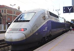
From 1981 onwards, a newly-constructed set of high-speed LGV (Lignes à Grande Vitesse) lines linked France's most populous areas with the capital, starting with Paris-Lyon. In 1994, the Channel Tunnel opened, connecting France and Great Britain by rail under the English Channel. The TGV has set many world speed records, the most recent on 3 April 2007, when a new version of the TGV dubbed the V150 with larger wheels than the usual TGV, and a stronger 25,000 hp (18,600 kW) engine, broke the world speed record for conventional rail trains, reaching 574.8 km/h (357.2 mph).[3]
Trains, unlike road traffic, drive on the left (except in Alsace-Moselle). Metro and tramway services are not thought of as trains and usually follow road traffic in driving on the right (except the Lyon Metro).
Rail links to adjacent countries
- Same gauge
.svg.png) Belgium — voltage change 25 kV AC/3 kV DC (except high-speed line to Bruxelles, same voltage)
Belgium — voltage change 25 kV AC/3 kV DC (except high-speed line to Bruxelles, same voltage) Germany — voltage change 25 kV AC/15 kV AC
 Great Britain via the Channel Tunnel — voltage change 25 kV AC/750 V DC third rail (except high-speed line to London, same voltage)
 Italy — voltage change 25 kV AC/3 kV DC
 Luxembourg — same voltage
 Switzerland — voltage change 25 kV AC or 1,5 kV DC/15 kV AC
 Monaco
- Break-of-gauge, 1,435 mm (4 ft 8 1⁄2 in)/1,668 mm (5 ft 5 2⁄3 in)
 Spain — voltage change 1,5 kV DC/3 kV DC
- No rail link to
 Andorra
Trams and Light Railways
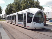
In spite of the closure of most of France's tram systems in earlier years, a fast growing number of France's major cities have modern tram or light rail networks, including Paris, Lyon (Lyon having the biggest one), Montpellier, Saint-Étienne, Strasbourg and Nantes . Recently the tram has seen a very big revival with many experiments such as ground level power supply in Bordeaux, or trolleybuses pretending to be trams in Nancy.[4]
This way of travelling started disappearing in France at the end of the 1930s. Only Lille, Marseille and Saint-Étienne have never given up their tram systems. Since the 1980s, several cities have re-introduced it.
The following French towns and cities run light rail or tram systems:
- Bordeaux - since 2003;
- Caen - since 2002, 'trams on tyres' system featuring a single guide rail while running on tyres;
- Clermont-Ferrand - since 2006, 'trams on tyres';
- Grenoble - since 1987;
- Île-de-France - (Paris metropolitan area) - since 1992
- Lille, Roubaix and Tourcoing - non-stop since 1909;
- Lyon - since 2001;
- Le Mans - since 2007;
- Marseille - since 2007;
- Montpellier - since 2000;
- Mulhouse - since 2006
- Nancy - since 2000, 'trams on tyres' system featuring a single guide rail while running on tyres;
- Nice - since 2007;
- Nantes - since 1985;
- Orléans - since 2000;
- Rouen - since 1994;
- Saint-Étienne - non-stop since 1881;
- Strasbourg - since 1994 and
- Valenciennes - since 2006
Light rail and tram systems are under construction in Angers and Toulouse.
Systems are planned in Brest, Le Havre, Reims, Tours, Besançon and Fort-de-France.
The revival of tram networks in France has brought about a number of technical developments both in the traction systems and in the styling of the cars:
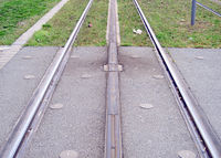
- APS third rail: The ground-level power supply system known as APS or Alimentation par le sol uses a third rail placed between the running rails, divided electrically into eight-metre segments with three metre neutral sections between. Each tram has two power collection skates, next to which are antennas that send radio signals to energise the power rail segments as the tram passes over them. At any one time no more than two consecutive segments under the tram should actually be live. Alstrom developed the system primarily to avoid intrusive power supply cables in sensitive area of the old city of Bordeaux.[5]
- Modern styling: The Eurotram, used in Strasbourg, is part of the Flexity Outlook series developed by Bombardier. The Eurotram has a modern design that makes it look almost as much like a train as a tram, and has large windows along its entire length.[6]
- Modular design: The Citadis tram, flagship of the French manufacturer Alstom, enjoys an innovative design combining lighter bogies with a modular concept for carriages providing more choices in the types of windows and the number of cars and doors.[7] The recent Citadis-Dualis, intended to run at up to 100 km/h, is suitable for stop spacings ranging from 500 m to 5 km. Dualis is a strictly modular partial low-floor car, with all doors in the low-floor sections.[8]
Roads
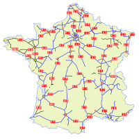
There are 1,000,960 km of roads in France.[2] The French motorway network or autoroute system consists largely of toll roads, except around large cities and in parts of the north. It is a network totalling 12,000 km (7,450 miles) of motorways operated by private companies such as Sanef (Société des autoroutes du Nord et de l'Est de la France). It has the fourth largest highway network in the world, trailing only the United States, Canada and Germany.
France currently counts 30,500 km of major trunk roads or routes nationales and state-owned motorways. By way of comparison, the routes départementales cover a total distance of 365,000 km. The main trunk road network reflects the centralising tradition of France: the majority of them leave the gates of Paris. Indeed, trunk roads begin on the parvis of Notre-Dame of Paris at Kilometre Zero. To ensure an effective road network, new roads not serving Paris were created.
France is believed to be the most car dependent country in Europe. In 2005, 937 billion vehicle kilometres were travelled in France (85% by car).[2]
Waterways/Canals
.jpg)
The French natural and man-made waterways network is the largest in Europe[9] extending to over 8,500 kilometres (5,300 mi) of which (VNF, English: Navigable Waterways of France), the French navigation authority, manages the navigable setions. The assets managed by VNF comprise 6,700 kilometres (4,200 mi) of waterways, made up of 3,800 kilometres (2,400 mi) of canals and 2,900 kilometres (1,800 mi) of navigable rivers, 494 dams, 1595 locks, 74 aqueducts, 65 reservoirs, 35 tunnels and a land area of 800 km2 (309 sq mi).[10] Two significant waterways not under VNF's control are the navigable sections of the River Somme and the Brittany Canals, which are both under local management.
Approximately 20% of the network is suitable for commercial boats of over 1000 tonnes[11] and the VNF has an ongoing programme of maintenance and modernisation to increase depth of waterways, widths of locks and headroom under bridges to support France's stategy of encouraging freight onto water.[12]
Marine transport

France has an extensive merchant marine, including 55 ships of size GRT|1,000 and above. The country also maintains a captive register for French-owned ships in Iles Kerguelen (French Southern and Antarctic Lands).
French companies operate over 1,400 ships of which 700 are registered in France. France's 110 shipping firms employ 12,500 personnel at sea and 15,500 on shore. Each year, 305 million tonnes of goods and 15 million passengers are transported by sea. Marine transport is responsible for 72% of France's imports and exports.[13]
France also boasts a number of seaports and harbours, including Bayonne, Bordeaux, Boulogne-sur-Mer, Brest, Calais, Cherbourg-Octeville, Dunkerque, Fos-sur-Mer, La Pallice, Le Havre, Lorient, Marseille, Nantes, Nice, Paris, Port-la-Nouvelle, Port-Vendres, Roscoff, Rouen, Saint-Nazaire, Saint-Malo, Sète, Strasbourg and Toulon.
Air Travel
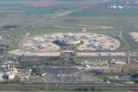
There are approximately 478 airports in France (1999 est.) and by a 2005 estimate, there are three heliports. 288 of the airports have paved runways, with the remaining 199 being unpaved.
Among the airspace governance authorities active in France, one is Aéroports de Paris, which has authority over the Paris region, managing 14 airports including the two busiest in France, Charles de Gaulle Airport and Orly Airport. The former, located in Roissy near Paris, is the fifth busiest airport in the world with 60 million passenger movements in 2008, and France's primary international airport, serving over 100 airlines.
The national carrier of France is Air France, a full service global airline which flies to 20 domestic destinations and 150 international destinations in 83 countries (including Overseas departments and territories of France) across all 6 major continents.
References
- ↑ Les grands secteurs économiques Ministère des Affaires étrangères Retrieved 4 November 2007
- ↑ 2.0 2.1 2.2 "Transport in France". International Transport Statistics Database. iRAP. http://www.iraptranstats.net/fr. Retrieved 2009-02-17.
- ↑ Associated Press (2007-04-03). "French Train Hits 357 mph (575 km/h) Breaking World Speed Record". http://www.foxnews.com/story/0,2933,263542,00.html. Retrieved 2007-04-03.
- ↑ "French rediscover love for streetcars". UPI (Paris). 2008-07-18. http://www.upi.com/Top_News/2008/07/18/French_rediscover_love_for_streetcars/UPI-82771216410359/. Retrieved 2008-08-13.
- ↑ Allez le Tram from Railway-Technology.com. Retrieved 15 February 2009.
- ↑ Porto:Metro from NYCsubway.org. Retrieved 15 February 2009.
- ↑ Georges Dobias: Urban Transport in France from Japan Railway & Transport Review, 16 June 1998. Retrieved 15 February 2009.
- ↑ Dualis extends the reach of the Citadis family from Railway Gazette, 2 June 2007. Retrieved 15 February 2009.
- ↑ "Waterways development". VNF. http://www.vnf.fr/vnf/content.vnf?action=content&occ_id=4550. Retrieved 2008-10-29.
- ↑ "Presentation complete" (in French). VNF. http://www.vnf.fr/vnf/img/cms/Tourisme_et_domainehidden/plaquette_200802041720.pdf. Retrieved 2008-10-29.
- ↑ "Questions and Answers". VNF. http://www.vnf.fr/vnf/faq.vnf?action=byType&type=missions. Retrieved 2008-10-29.
- ↑ Voies navigables de France: conjuguer économie et écologie. Retrieved 19 February 2009.
- ↑ Le transport maritime from Armateurs de France (in French). Retrieved 20 February 2009.
|
||||||||||||||